A 9.9-magnitude earthquake hits the Philippine Islands Region on Friday night, August 31, 2012 at around 08:47:34 PM at epicenter.
See details on images below:
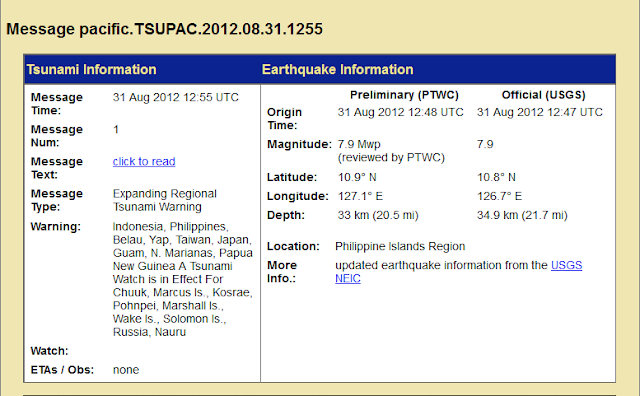
From NOAA's National Weather Service Pacific Tsunami Warning Center:
From coolbuster:
A powerful earthquake measured at Magnitude 7.9 has hit Sulangan in Eastern Samar, Philippines around 8:50 pm on Friday, August 31, 2012.
According to the United States Geological Survey (USGS), the earthquake’s epicenter, which has a depth of 33.00 km or 20.51 miles, was located 139 kilometers East of Sulangan, or 161 km (100 miles) East Southeast of Borongan and 174 km (108 miles) Northeast of Surigao.
It was felt in most of Mindanao and the Visayas regions including the cities of Cagayan de Oro, Davao, Cebu, Bohol and Tacloban.
According to @RescuePH on Twitter, PHIVOLCS recorded the earthquake, which lasted about 30 seconds, at 7.7 magnitude.
The agency also reportedly said that “due to the strength of the earthquake, the formation of a tsunami is possible.”
PHIVOLCS issued Tsunami Alert Level 3, according to @RescuePH. According to PHIVOLCS director Renato Solidum, a tsunami alert has been raised in coastal areas of Surigao del Norte, Southern Leyte, and Samar.
Reports said that residents living in coastal areas in Northern and Eastern Samar, Leyte, Surigao del Sur, and Surigao Norte have been urged to evacuate and were advised to cooperate with their respective local government units (LGUs).
Solidum said the estimated wave height of the possible tsunami is around 1 meter to 1.5 meters.
Meanwhile, the Pacific Tsunami Warning Center has issued an “Expanding Regional Tsunami Warning” over Indonesia, Philippines, Belau, Yap, Taiwan, Japan, Guam, N. Marianas, and Papua New Guinea.
A Tsunami Watch is in effect for Chuuk, Marcus Island, Kosrae, Pohnpei, Marshall Island, Wake Island, Solomon Island, Russia, and Nauru.


